Is Japan an Island? 14,125 Islands and How They Connect

So when people ask whether Japan is an island, the honest answer is that it is an island country. The land you fly into is a long chain of Japan islands, large and small. Tokyo, Kyoto and Osaka all sit on Honshu, the largest one. Sapporo is on Hokkaido, Fukuoka is on Kyushu, Takamatsu is on Shikoku and Naha is on Okinawa Island.
The GSI press release on counting Japan’s islands explains where the number comes from. GSI is the Geospatial Information Authority of Japan. This guide covers what the count means and which islands hold the big cities. It also shows how they join up and how long each takes from Tokyo.
How many islands Japan has
GSI is the national mapping agency of Japan. In 2023 it counted islands on its detailed digital base map of the country. That map showed 120,729 separate pieces of land as of January 2022. GSI only judged the pieces with a coastline of 0.1 km or more, and kept the ones that formed naturally. Islands named in Japanese law were counted too. The result was 14,125 islands.
For decades, books and websites said Japan had 6,852 islands. That number came from the Japan Coast Guard, which published it in 1987. The GSI FAQ on the number of Japan’s islands says the new count used the same 0.1 km coastline rule as the Coast Guard survey.
So why did the number more than double? GSI says it did not discover new islands. Survey methods have improved, and today’s maps draw the coastline in far more detail. Small rocks and islets that older maps merged or left out now appear as their own shapes, so they get counted.
The definition of an island comes from the United Nations Convention on the Law of the Sea, which Japan ratified in 1996. Under that treaty, an island is naturally formed land, surrounded by water, that stays above water at high tide. Land smaller than the 0.1 km cutoff can still be an island under the treaty. It just falls outside the count.
The new number does not change Japan’s land area or its territorial waters. GSI measures land area from every piece of land on the map, whatever the island count says. It also expects the count to move again, because erosion, rising seas and volcanic activity keep changing the coast.
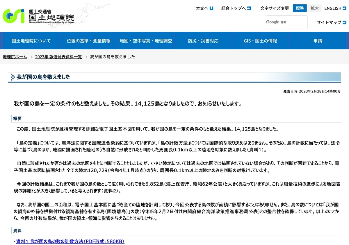
The screenshot shows that GSI announcement as it appears on the agency’s site, in Japanese. Its headline reads 我が国の島を数えました (wagakuni no shima o kazoemashita). That means “We counted our country’s islands.” The word 島 (shima) means island. You will see it on ferry signs across the country.
The five big islands and their cities
Most visitors only need the names of five Japan islands. Four of them carry almost all of the country’s big cities, and the fifth is Okinawa’s main island. Here is where the places you have heard of actually are.
- Honshu is the main island and the largest. Tokyo, Kyoto, Osaka, Hiroshima and Okayama are all on it.
- Hokkaido is the northern island. Sapporo, Hakodate and Otaru are its best-known cities.
- Kyushu lies to the southwest. Fukuoka, whose main station is Hakata, and Kumamoto are here.
- Shikoku faces Honshu across the Seto Inland Sea. Takamatsu in Kagawa is the usual entry point.
- Okinawa Island is far to the south. Naha is the capital and has the main airport.
| Island | Main cities | Where most travellers arrive |
|---|---|---|
| Honshu | Tokyo, Kyoto, Osaka, Hiroshima, Okayama | Tokyo Station, Haneda, Narita |
| Hokkaido | Sapporo, Hakodate, Otaru | New Chitose Airport (33 min to Sapporo by JR) |
| Kyushu | Fukuoka (Hakata), Kumamoto | Hakata Station |
| Shikoku | Takamatsu, Sakaide | Takamatsu Airport or the Seto Ohashi Bridge by train |
| Okinawa Island | Naha | Naha Airport |
The table lists each island with its main cities and the arrival point most travellers use. On Hokkaido, New Chitose Airport has its own JR station, and the JR Rapid Airport reaches Sapporo in 33 minutes for 1,230 yen. On Shikoku, Takamatsu Airport serves Takamatsu and Kotohira. On Okinawa Island, Naha Airport sits close to central Naha.
If you want the size of a particular island, the GSI Q&A on Japan’s land and territory explains where to look. GSI publishes the area of every island of 1 km² or more in its national area survey. It does not measure islands smaller than that one by one. Since 2019, it has recalculated areas four times a year from its digital map.
How the big islands connect to Honshu
Three of the four other big islands join Honshu by rail. That means you can ride from Tokyo to Hokkaido, Shikoku or Kyushu without boarding a plane or a ferry. Each link works in a different way.
Shikoku: the Seto Ohashi Bridge
The Japan Tourism Agency Seto Ohashi Bridge description gives the key facts. The bridge is 13 km long and connects Okayama Prefecture on Honshu with Kagawa Prefecture on Shikoku. It is really 10 two-tier bridges joined in a row. Cars use the upper deck and trains use the lower deck.
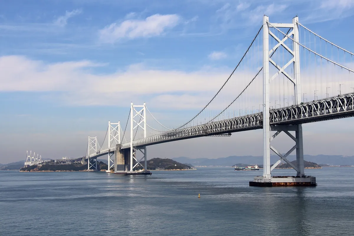
The photo shows the bridge stepping across the Seto Inland Sea from island to island. Builders spent 10 years on it, from 1978 to 1988. Driving across takes about 15 minutes. The train between Kojima Station in Okayama and Utazu Station on the Shikoku side takes about the same time. Seto Ohashi Memorial Park in Sakaide has a free museum about the build, and the 108-meter Seto Ohashi Tower looks out over the whole bridge.
Hokkaido: the Shinkansen under the strait
The Hokkaido Shinkansen uses the Seikan Tunnel, under the sea between Honshu and Hokkaido. The Hayabusa leaves Tokyo Station and runs straight through to Shin-Hakodate-Hokuto Station. At Shin-Hakodate-Hokuto you change to the Hakodate Liner for Hakodate or the Limited Express Hokuto for Sapporo.
Kyushu: the Sanyo Shinkansen
The Sanyo Shinkansen runs from Shin-Osaka to Hakata Station in Fukuoka. The Nozomi from Tokyo continues onto this line and reaches Hakata in 4 h 52 min. You stay in the same seat the whole way from Tokyo.
Okinawa: no rail or road link
Okinawa Island has no bridge or tunnel to the rest of Japan. You fly. The table below puts the four links side by side.
| Island | Link to Honshu | Quickest trip from Tokyo |
|---|---|---|
| Hokkaido | Hokkaido Shinkansen through the Seikan Tunnel | Hakodate by train: 4 h 29 min, 24,530 yen |
| Shikoku | Seto Ohashi Bridge, 13 km, built 1978 to 1988 | Shinkansen to Okayama, then a train over the bridge |
| Kyushu | Sanyo Shinkansen, Shin-Osaka to Hakata | Hakata by Nozomi: 4 h 52 min |
| Okinawa Island | No rail or road link | Haneda to Naha by air: 2 h 30 min |
Read the table from left to right: the island, what joins it to Honshu, and the quickest public trip from Tokyo in our data. Only Okinawa Island needs a plane.
Getting from Tokyo to each big island
Use this section to choose between the train and a flight for each island. Times come from our route pages, which list each operator’s own timetable. Flight times do not include getting to the airport.
The details follow.
Hokkaido: Hakodate by train, Sapporo by air
Tokyo to Hakodate works well by rail. The Hayabusa and the Hakodate Liner take 4 h 29 min from Tokyo Station and cost 24,530 yen. A flight from Haneda to Hakodate Airport takes 1 h 15 min, with 9 flights a day between 07:15 and 18:25.
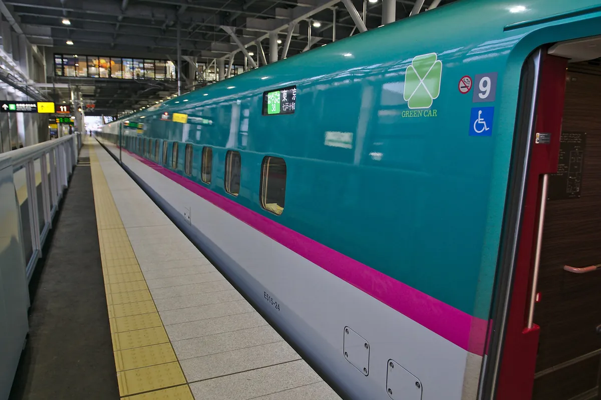
The photo shows a Hokkaido Shinkansen train, which you would ride as far as Shin-Hakodate-Hokuto. For Tokyo to Sapporo, the train takes 7 h 45 min and costs 30,120 yen, using the Hayabusa and the Limited Express Hokuto. A flight from Haneda to New Chitose Airport takes 1 h 30 min. There are 56 flights a day on the 14 October 2026 timetable, the first at 06:20 and the last at 21:30. From Narita, the flight takes 1 h 45 min and runs 17 times a day.
After you land at New Chitose, the JR Rapid Airport to Sapporo takes 33 minutes for 1,230 yen. The airport bus takes 63 or 74 minutes for 1,500 yen, depending on the line.
Kyushu: Fukuoka by Shinkansen
For Tokyo to Fukuoka, the Nozomi reaches Hakata in 4 h 52 min. If you plan to keep travelling around Kyushu, JR Kyushu sells the SUGOMON PASS IC card only to visitors from abroad. It costs 2,000 yen with 1,500 yen loaded, and you buy it at the Hakata or Kumamoto station ticket office with your passport.
Shikoku: Takamatsu by rail or air
To reach Shikoku by train, take the Shinkansen west to Okayama. From there a local train crosses the Seto Ohashi Bridge to Kagawa. If you would rather fly, Takamatsu Airport has buses into Takamatsu and to Ritsurin Garden.
Okinawa: Naha by air only
A flight from Haneda to Naha Airport takes 2 h 30 min. Our Tokyo to Okinawa page lists 35 flights a day, and there is no train option. The Naha Airport page shows the ways into central Naha.
Smaller islands worth the trip
Beyond the big five, a few smaller islands are easy to fit into a first trip. Each has a ferry or a bus link that our pages track.
Miyajima, off Hiroshima
Miyajima is a small island in the Seto Inland Sea, home to Itsukushima Shrine and its torii gate in the sea. Osaka to Miyajima takes about 2 h 5 min by Nozomi, the JR Sanyo Line and the JR ferry. You can do it as a day trip from Osaka or Kyoto.
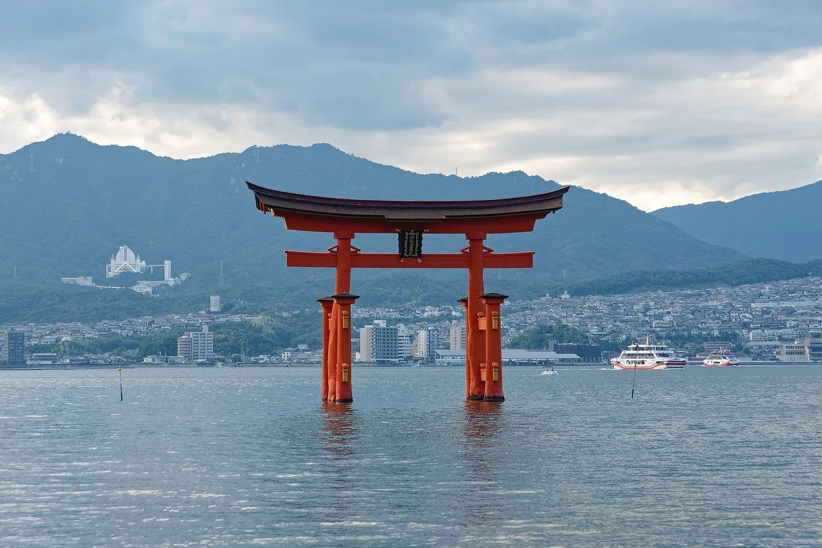
The photo shows the shrine’s red torii standing in the water off Miyajima. At high tide the gate looks like it floats, so check the tide before you go.
The Seto Inland Sea islands
The Seto Inland Sea between Honshu and Shikoku is dotted with islands. You can see many of them from the Seto Ohashi Tower in Sakaide or from the train window as you cross the bridge.
Ishigaki and the Yaeyama islands
Ishigaki is far south of Okinawa Island. New Ishigaki Airport is the gateway to the Yaeyama islands and also handles some international flights. New Ishigaki Airport to Ishigaki Port takes 32 minutes by route bus for 550 yen, or about 25 minutes by taxi for about 3,500 yen. Ferries for Taketomi and Iriomote leave from that port.
The New Ishigaki Airport page also lists the bus to Kabira Park, which takes 42 minutes and costs 860 yen. You can send bags on from the airport or leave them at a staffed baggage counter.
Weather from Hokkaido to Okinawa
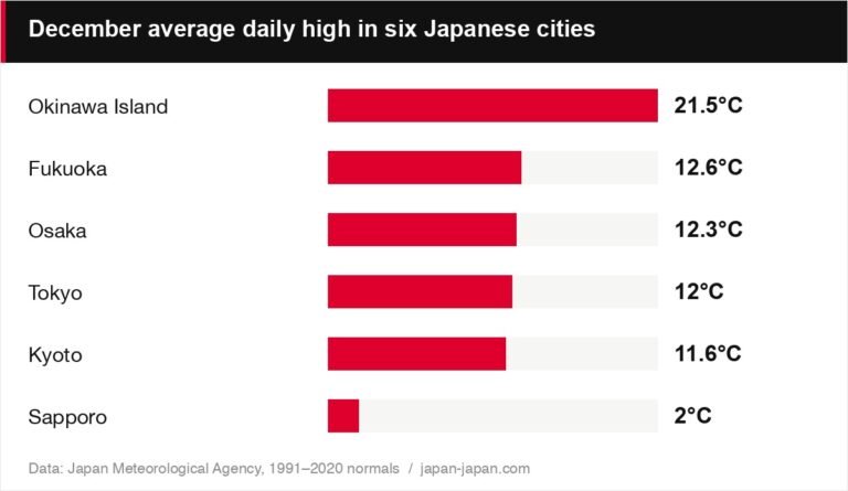
Japan’s islands stretch a long way from north to south, so winter feels very different at each end. Sapporo gets heavy snow, while Naha stays mild enough for a light jacket.
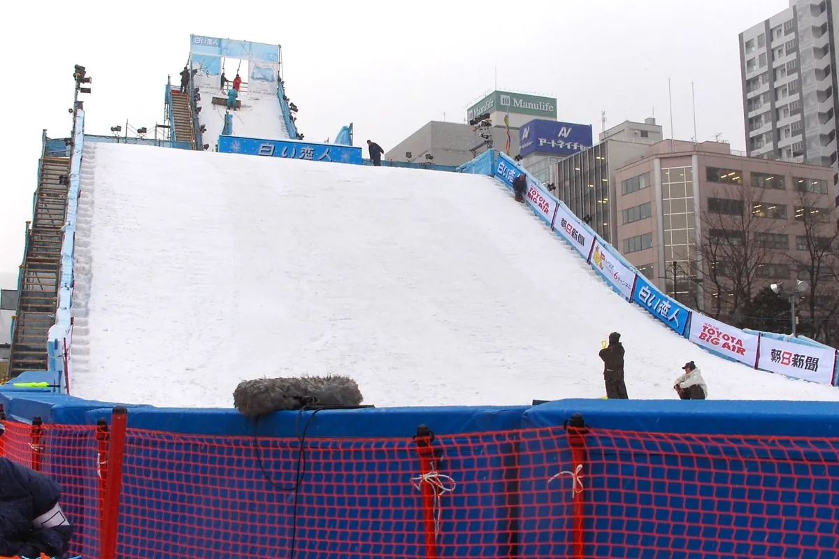
The photo shows Odori Park in central Sapporo under winter snow. If your trip falls between December 2026 and February 2027, pack two sets of clothes for a north and south route.
The Japan Meteorological Agency climate normals are the official long-term averages. JMA bases them on the 30 years of observations from 1991 to 2020. Our Japan temperature by month guide turns those normals into highs, lows, rain and snow for six cities, including Sapporo and Naha.
For a single place, see Sapporo by month and Okinawa by month. Both pages show what each month looks like and which events fall in it.
Planning a trip across the islands
Two or three big islands fit easily into one rail trip. Add a single flight if Okinawa is on the list. Start with the pass, then add the flight, then leave a full day for each long move.
Here is how each one plays out.
Pick a rail pass that crosses the water
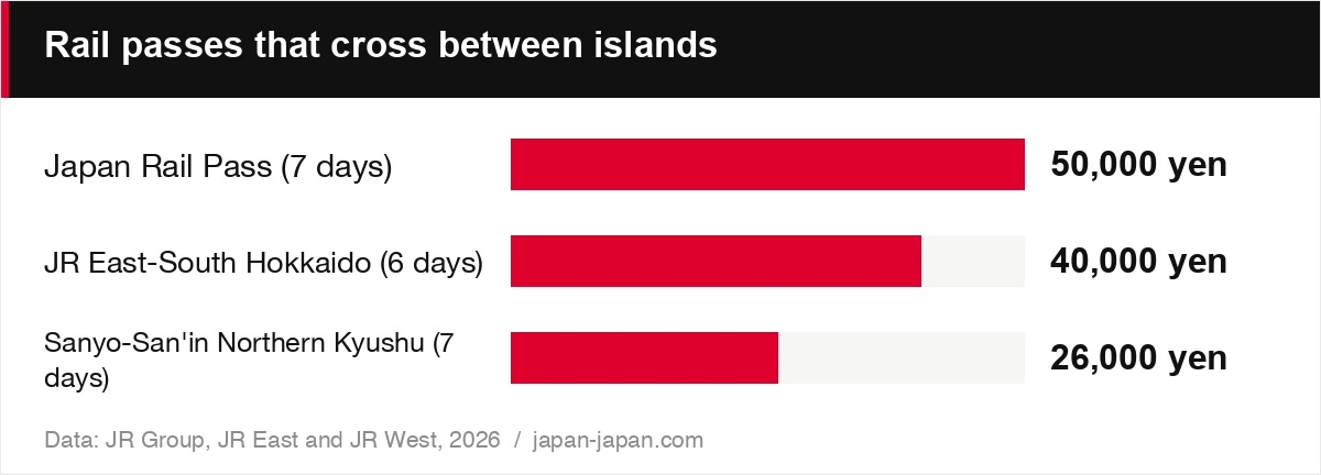
The Japan Rail Pass costs 50,000 yen for 7 days in an ordinary car. Children pay 25,000 yen. It also comes in 14 and 21 days. It covers all JR Group trains, including the Shinkansen, except the Nozomi and Mizuho. That covers the Hayabusa to Hokkaido and the local trains over the Seto Ohashi Bridge.
Two regional passes cover one crossing each for less money. The JR East-South Hokkaido Rail Pass costs 40,000 yen for 6 days. It covers JR East lines and JR Hokkaido lines around Hakodate, Sapporo and Otaru. The Sanyo-San’in Northern Kyushu Pass costs 26,000 yen for 7 days. It covers the Sanyo Shinkansen from Shin-Osaka to Hakata, including reserved seats. Neither regional pass covers the Tokaido Shinkansen.
| Item | Value | Note |
|---|---|---|
| Japan Rail Pass (7 days) | 50,000 yen | All JR trains except Nozomi and Mizuho |
| JR East-South Hokkaido (6 days) | 40,000 yen | Tokyo to Hakodate, Sapporo and Otaru |
| Sanyo-San’in Northern Kyushu (7 days) | 26,000 yen | Shin-Osaka to Hakata |
The chart compares the adult price of each pass. Choose the regional pass if your trip stays in one corner of the country.
Add Okinawa with a domestic flight
No pass gets you to Okinawa Island, so book a flight. If you fly home from New Chitose, Naha or Fukuoka, you can do the tax-free customs check online with Visit Japan Web. Japan offers that at 7 airports.
Leave a travel day for each long move
The train from Tokyo to Sapporo takes 7 h 45 min. That fills most of a day. If you want a ready-made route on the main island first, our 10-day Japan itinerary for first-timers covers Tokyo, Hakone, Kyoto and Osaka. Add Hokkaido or Kyushu to either end of it.
FAQ
How many main islands does Japan have?
Japan is usually described around four main islands: Honshu, Hokkaido, Kyushu and Shikoku. Travel guides often add Okinawa Island as a fifth, because Naha is a common stop. Together these five hold almost all of the big cities a visitor sees.
What is the largest island in Japan?
Honshu is the largest island. Tokyo, Kyoto, Osaka and Hiroshima are all on it. GSI publishes the area of every island of 1 km² or more in its national area survey.
Can you take a train from Tokyo to Hokkaido?
Yes. The Hayabusa runs from Tokyo Station to Shin-Hakodate-Hokuto through the Seikan Tunnel. With the Hakodate Liner, Tokyo to Hakodate takes 4 h 29 min for 24,530 yen. Tokyo to Sapporo by train takes 7 h 45 min, while the flight from Haneda takes 1 h 30 min.
Why did Japan’s island count change to 14,125?
GSI counted again in 2023 on a far more detailed digital map. It used the same 0.1 km coastline rule as the Japan Coast Guard count of 6,852 from 1987. The rise comes from better maps, not new islands, and it does not change Japan’s land area or territory.
About the author