Nakasendo Trail Map: Magome to Tsumago and Narai Routes
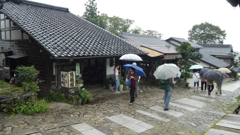
The JNTO Nakasendo hiking trails feature lists these walks with access times from Nagoya. This guide puts them in one order from south to north, so you can see where each section starts and ends. It then compares the three options in one table.
Most visitors only walk one section. The Magome to Tsumago path is well kept, signposted and easy to fit into one day. The Yabuhara to Narai path is shorter on paper but slower, because it climbs over the highest point of the whole road.
The Nakasendo trail map of the Kiso Valley
The Nakasendo was the longest of the Gokaido, the five main roads of the Edo period (1603-1867). It linked Kyoto and Tokyo over about 534 km, with 69 post towns along the way. The post towns were called juku, which is why you see names like Magome-juku and Tsumago-juku on signs.
The Japan Tourism Agency Nakasendo interpretive text gives the full road as roughly 530 km, with an average width of 2.7 m. It also names the Kiso valley stretch as 80 km long. The JNTO Kiso Valley destination page gives a different figure: 70 km through Kiso. It counts 11 post towns, from Magome in the south to Niekawa in the north. The two numbers come from two official pages, so treat the valley as 70 to 80 km depending on where you draw the line.
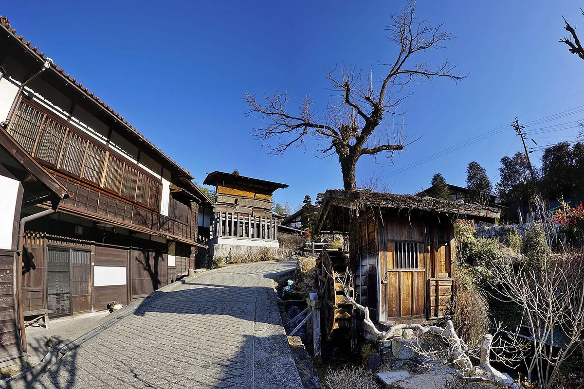
The photo above shows the old wooden street of Tsumago, one of the post towns at the southern entrance to the valley. Read the valley from south to north and the main stops fall in this order:
- Magome: the southern start, in Nakatsugawa City, Gifu Prefecture.
- Tsumago: the next post town, in Nagiso Town, Nagano Prefecture, reached on foot over Magome Pass.
- Kiso-Fukushima: the largest town in Kiso and the old checkpoint, near the middle of the valley.
- Yabuhara: the start of the walk over Torii Pass.
- Narai: the long post town on the far side of the pass, in the northern part of the valley.
- Niekawa: the last of the 11 Kiso post towns at the northern end.
The Shinano Express runs the full length of the Kiso Valley. That train line is the spine of any Nakasendo trip here. You ride it between sections and walk the parts that are best preserved.
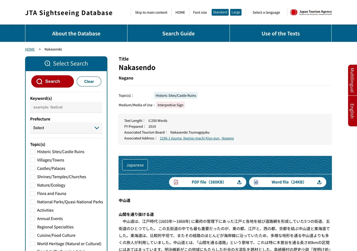
This screen is the Japan Tourism Agency’s English text on the Nakasendo, written for signs at the site. It explains that the name means “road through the mountains”. It also quotes Shimazaki Toson’s novel Before the Dawn: “The Kiso Road lies entirely in the mountains”.
Magome to Tsumago: 8 to 9 km, step by step
This is the walk most people mean when they search for a Nakasendo trail map. JNTO calls it perhaps the most popular route on the road. The JNTO Nakatsugawa destination page describes an 8 km path, and the JNTO Tsumago spot page gives a 9 km, three-hour walk. Plan for 8 to 9 km and 2.5 to 3 hours on foot.
Magome sits on a slope. The name means “horse basket,” because travellers once left their horses at inns before the steep path. Try gohei-mochi, toasted rice cakes with a walnut, sesame and soy sauce glaze, before you set off.
From Magome you walk over Magome Pass toward Tsumago. A traveller’s story on the JNTO Walking the Nakasendo from Magome to Tsumago page describes shrines, waterfalls, bamboo groves and terraced rice paddies. Part of the forest path still has large, rough stones laid in the early 1600s. The same page says the route has more downhill if you start in Magome.
Here is the same order with the details.
- Send your bag. Baggage delivery runs between Magome and Tsumago. Hand in your large bag in Magome and collect it at your end point.
- Climb to Magome Pass. The trail runs through a cypress forest. Bells hang along the path, and hikers are encouraged to rent a bell to scare off bears. Ring them as you pass.
- Stop at the teahouse. At Ichikoku Tochi you reach Tateba-Jaya, a teahouse about 200 years old.
- Walk down to Tsumago. Look for the Otaki and Medaki waterfalls, the “Men’s Falls” and “Women’s Falls,” just outside the town.
The Japan Tourism Agency Tateba-Jaya teahouse text explains the stop. Ichikoku Tochi was once a hamlet of seven buildings, including a guardhouse that checked shipments of wood. Inside the teahouse you find a packed-earth floor, an irori hearth and two tatami rooms. The Friends of Tsumago, the local conservation group, manages it today. They invite walkers to drop in for a cup of tea.
Tsumago was the 42nd station on the Nakasendo. In 1968 the local council decided to preserve the main street. Cars cannot use the main road during the day, and power lines are hidden from view. Visit the Nagiso Town Museum, which includes the Wakihonjin Okuya, a former inn for high-status guests rebuilt in 1877 from hinoki cypress. A group of locals met around its hearth in 1967 and started Japan’s first town preservation movement.
At both ends of the walk, look for kosatsu. These old noticeboards stand at the entrances of Tsumago and Magome and once carried rules from the military government.
Yabuhara to Narai over Torii Pass
The second walk sits in the northern half of the valley. The trail from Yabuhara to Narai crosses Torii Pass, the highest point of the Nakasendo. JNTO gives it as about 6 km and three to three and a half hours. That is slower per kilometre than Magome to Tsumago, because most of the time goes into the climb.
You start at Yabuhara Station. Local trains stop there from Nakatsugawa Station, but not often. Check the timetable before you leave, so you do not wait at a small station for your train.
After the pass you reach Ontake Shrine, which honours Mount Ontake. The path then drops into Narai, the longest town on the Nakasendo. Its main road runs about 1 km and is lined with Edo-style buildings. Because of all those houses, people called it “Narai of a Thousand Houses,” and it was one of the richest post towns of its time.
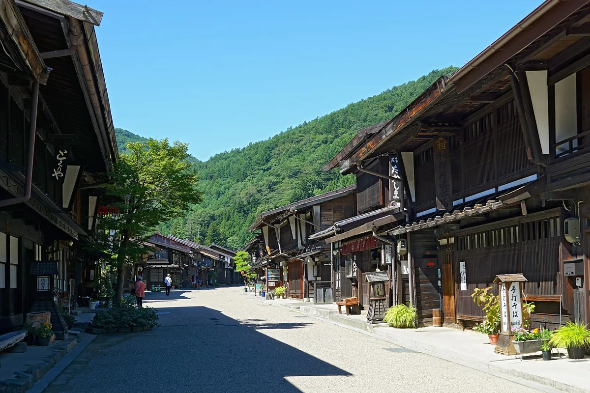
The photo shows Narai’s long main street. The JNTO Kiso page says the town is best in the evening, when lanterns light the old buildings. Narai is known for soba. Nearby Hirasawa is a lacquerware district, so many shops sell red and black bowls, chopsticks and trays.
If you can travel in early June, Narai holds the Kiso Lacquerware Festival and the Narai Post Festival. For the rest of the year, plan the walk around daylight and the train times at Yabuhara.
Kiso-Fukushima, the halfway checkpoint
Kiso-Fukushima is the halfway point of the Nakasendo and the most important post town in the Kiso Valley. It has nothing to do with Fukushima Prefecture. Here the shogunate ran a checkpoint, or sekisho. No traveller could pass without an official permit, and guards inspected their goods. The JNTO Kiso page says the checkpoint kept tight control over people, goods and guns.
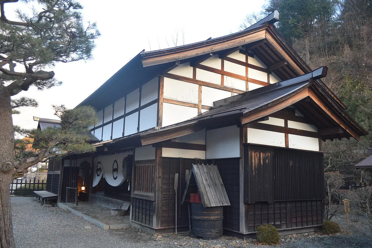
The photo shows the checkpoint area. Today you can visit the sekisho and the Yamamura Residence, the magistrate’s mansion. Both hold weapons, clothing and other objects from the period.
Use Kiso-Fukushima as a stop between the two walks. It is Kiso’s largest town, with houses above the Kiso River and several old streets. Kozenji Temple is one of the three great temples of the Kiso Valley and has Asia’s largest dry rock garden. To the west stands Mount Ontake, at 3,067 m the second highest volcano in Japan after Mount Fuji. The town is also known for soba and sake.
From JR Nagoya Station, Kiso-Fukushima is about 1.5 hours on the Shinano Express on the JR Chuo Line. From the north, the same train runs straight from Nagano City or Matsumoto.
Getting to the trailheads from Nagoya, Tokyo and Osaka
Nagoya is the gateway. From JR Nagoya Station, take the Shinano Express on the JR Chuo Main Line to Nakatsugawa Station in around 50 minutes. Then ride a 25-minute bus to Magome-juku. That makes about 75 minutes from Nagoya to the start of the walk, plus waiting time for the bus.
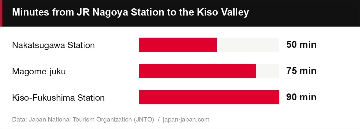
| Item | Value | Note |
|---|---|---|
| Nakatsugawa Station | 50 min | Shinano Express |
| Magome-juku | 75 min | 50 min train + 25 min bus |
| Kiso-Fukushima Station | 90 min | About 1.5 hours |
The chart compares travel times from JR Nagoya Station. Nakatsugawa takes about 50 minutes, Magome about 75 with the bus, and Kiso-Fukushima about 90. Yabuhara takes 2 to 3 hours by local train on the Chuo Line, with few stops, so check the schedule first.
To start in Tsumago instead, ride the Shinano Express to Nagiso Station. From Nagiso, Tsumago is a 10-minute bus ride. Buses are infrequent, but taxis wait at the station.
From Tokyo, take the Tokaido Shinkansen to Nagoya and change to the Shinano Express. Our Tokyo to Nagoya route page compares the trains on that leg. A second option from Tokyo is the JR Azusa from Shinjuku toward Matsumoto, changing to the Shinano Express at Shiojiri. That way reaches the northern towns, such as Narai and Kiso-Fukushima, first.
From Osaka or Kyoto, go to Nagoya first. The Osaka to Nagoya route page shows the Shinkansen times and fares. If you fly in, use Chubu Centrair Airport. The Meitetsu mu-SKY reaches Nagoya Station in 28 minutes for 1,430 yen, and the Meitetsu limited express takes 36 minutes for 980 yen. See Chubu Centrair Airport to Nagoya for all the options, and our Chubu Centrair Airport guide for lockers and baggage counters.
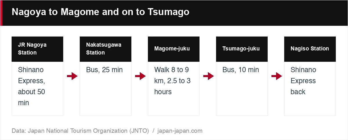
The flow above shows the full day for the classic walk. You take the train and bus out, walk to Tsumago, then ride a bus to Nagiso Station for the train home. The Japan Rail Pass covers JR limited express trains such as the Shinano, but no seat on the Nozomi. The 7-day pass costs 50,000 yen on the official website.
Which Nakasendo trail section fits your day
Pick the section by how much time you have and what you want to see. Magome to Tsumago fits a half day of walking and has the best-known streets. Yabuhara to Narai suits walkers who want a real mountain pass. Kiso-Fukushima suits people who want history without a long hike.
| Section | Distance and time | Where you start | Good for |
|---|---|---|---|
| Magome to Tsumago | 8 to 9 km, 2.5 to 3 hours | Magome-juku (25-minute bus from Nakatsugawa) | A first walk, more downhill from Magome |
| Yabuhara to Narai | About 6 km, 3 to 3.5 hours | Yabuhara Station (local train) | Crossing Torii Pass, the highest point |
| Kiso-Fukushima | Town visit, about 1.5 hours from Nagoya | Kiso-Fukushima Station | Checkpoint history without a long hike |
The table sets the three side by side. The walking times come from JNTO. The JNTO Tsumago page says the town is small enough to explore in half a day. The same page suggests a night at one of the inns, to see the street after the day crowds leave.
The drawing gives the same comparison in short form: distance, time and starting point for each stop. A few rules of thumb:
- One day from Nagoya: Magome to Tsumago. You leave Nagoya in the morning and can be back the same evening.
- Two days in the valley: Magome to Tsumago on day one, a night in Tsumago, then the train north to Kiso-Fukushima and Narai.
- Coming from Matsumoto: start with Narai and Yabuhara, then ride south.
The JNTO story page says you can cover Magome, Tsumago and the walk in one day, or stay overnight in a traditional inn. Inns there often serve a set dinner with no menu. If you do not eat certain foods, tell the staff when you check in.
Luggage, buses and walking late in the year
Three things decide whether the day goes smoothly: your bag, the bus and the local train. Sort them out the day before.
The checklist covers the four points to confirm before you start. Each one is explained below.
- Bags: baggage delivery runs between Magome and Tsumago. Send your bag to your end point and walk with a small pack. For moving a suitcase between cities, read our guide to luggage forwarding in Japan.
- Buses: buses from Nagiso Station to Tsumago are infrequent. Note the return times before you set off from Magome.
- Local trains: trains to Yabuhara stop rarely. Look up the timetable before you leave Nakatsugawa or Kiso-Fukushima.
- Direction: start in Magome if you want more downhill.
Plan around holidays too. Autumn is a popular time, with persimmons drying under the eaves. Our November holidays page lists Culture Day on 3 November and the other dates when Japanese travellers fill trains. For the year-end break, check the New Year 2026-27 page before you book.
Winter changes the walk. The JNTO story describes the Kiso area as a snowy, mountainous region. If you plan a walk late in the year, read our Japan packing list for winter and pack shoes with grip and warm layers.
FAQ
How long does it take to walk from Magome to Tsumago?
Plan for 2.5 to 3 hours. JNTO pages give the distance as 8 to 9 km. Add time for the teahouse and photo stops.
Should I start the Nakasendo walk in Magome or Tsumago?
Start in Magome if you want more downhill. The JNTO story on this walk recommends that direction. Starting in Tsumago also works if you arrive at Nagiso Station.
Can I send my luggage between Magome and Tsumago?
Yes. Baggage delivery runs between Magome and Tsumago, so you can send a heavy bag to your end point. Walk with a small pack for water and a rain layer.
How do I get to Magome from Nagoya?
Take the Shinano Express from JR Nagoya Station to Nakatsugawa Station, about 50 minutes. Then take the 25-minute bus to Magome-juku. The bus also connects to Tsumago-juku.
About the author